GLENN HEIGHTS — For years, the City of Glenn Heights has grown under two different sets of guidelines.
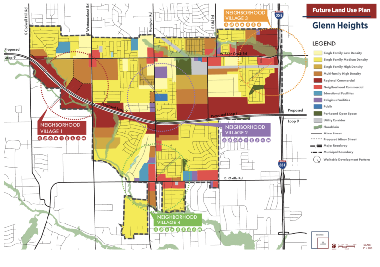
One is outlined in its Future Land Use Map — the city’s official blueprint for where different types of development should go. The other is reflected in actual zoning decisions, made case by case, lot by lot, meeting by meeting.
On Tuesday night, city leaders publicly acknowledged for the first time that these two approaches have not matched, and that the gap has only grown over the past years.
“What we did was, we decided to change zoning and not stick to what we said the future land use was going to be,” Planning and Zoning Commissioner Austin Kelley told a joint session of the City Council and the commission. “Now, we’re in this predicament that we have decided, and we have changed zoning, and now it needs to match the future land use. Zoning and the future land use need to say the same thing.”
Kelley, who has served on the commission since 2010, said he’s seen the shift firsthand as the city approved subdivision after subdivision of tightly packed homes.
“I’ve seen high-density come in because we were building houses close together, zero lots, and trying to put more houses in more communities,” Kelley said. “What that has done is that has changed our zoning map, and it has not coincided with our future land use.”
A Map From 2023, A City That’s Kept Changing
The current Future Land Use Map was adopted in 2023. Since then, the city has seen a wave of residential rezoning cases, even as its population climbs toward 30,000, according to previous reporting by Glenn Heights Future.
Bester Munyaradzi, the city’s Director of Planning & Development Services, explained why that matters. The future land use map, she said, is intended as the city’s long-range vision, a document that guides developers, residents and staff toward what Glenn Heights wants to become. Zoning, by contrast, determines what can be built today, parcel by parcel.
The problem, Munyaradzi said, is that the two have not been “speaking the same language.” Typically, when a landowner applies to rezone property, the city should check the request against the future land use map to ensure it aligns with the broader vision. But, as Kelley’s comments indicate, that step has not always occurred.
Mayor Brown pressed for clarity on what, exactly, the council needed to decide. She said the immediate task was not to rewrite the city’s long-term vision from scratch, but to ensure the ordinance language and the map use consistent definitions — since the two currently differ. Developers and residents who reference the city’s future land use map, she said, should see something that matches the reality on the ground.
A Push Towards Glenn Heights Commercial Growth
Beyond the technical fix, Tuesday’s meeting revealed a broader philosophical shift at City Hall. After years of residential approvals, Mayor Brown said she now wants the city’s next chapter to focus more on retail and commercial development — even as previously approved housing projects continue to be built.
Her focus is clear: the roughly 35% of Glenn Heights’ 7.2 square miles that remain undeveloped, which she said should be zoned for commercial use moving forward.
“I’m almost positive that if we build it, they will come,” Brown told the group. “In other words, if we build a strong, solid marketing plan, and we have our comprehensive land use maps, our future land use maps, our zoning, if we do what we need to do, the businesses will come.”
Councilwoman Washington echoed the concern, noting the fiscal reality of a city supported mostly by homes rather than businesses.
“Looking at the future, the city being primarily sustained by homes, I just cringe at the thought,” Washington said. “I just know that we need more commercial development to help balance that.”
There’s a practical reason for pursuing retail, too. Grocery stores and other commercial anchors generally prefer higher-density areas — more rooftops nearby means a larger customer base. But density has its drawbacks: city staff cautioned that infrastructure such as roads, water, and sewer systems must be able to support growth before it is approved.
Loop 9 and the widening of Bear Creek Road are both on the horizon for Glenn Heights, and Brown said those projects should shape how the city plans — not just for the next few years, but for decades to come.
“We’ve got to look long term, we’ve got to be visionaries, and it’s not just right now to the end of 2026, it’s not even to the end of 2030, right?” Brown said. “If we’re looking long term, we really need to consider really long term, and maybe we define what long term is for us.”
She put a finer point on it later: decisions made in 2026, should hold up for a city that looks ahead to 2056.
Defining The Fine Print
Much of the meeting’s technical work focused on something less headline-grabbing but just as crucial: defining what the city’s single-family zoning categories — SF-1, SF-2, SF-3 — actually mean. Council members and commissioners debated those definitions at length, since they form the foundation of how future rezoning requests will be evaluated against the map.
Councilwoman Washington said she had raised questions throughout the process not for her own benefit, but for residents watching at home. She wanted the public record to reflect why the meetings are being held and what is actually being decided.
What Happens Next
Any update to the Future Land Use Map requires two public hearings before it becomes official — one before the Planning and Zoning Commission and a second before the City Council. Neither has been scheduled yet, but Tuesday’s joint session was the first formal step toward getting the city’s map and its zoning ordinance to finally tell the same story.
Resident Jacque Bullock, who attended the meeting, said she left feeling encouraged.
“The Joint City Council and Planning and Zoning meeting was extremely informative as it pertains to aligning our zoning ordinance with our land use map,” Bullock said. “I was glad to hear that Mayor Brown wants the remaining 35% of available use to be zoned for only commercial development. Hopefully, the City Council and the Planning and Zoning Committee will move in accordance with the mayor’s mission to encourage more commercial development.”
How Glenn Heights Government Works
For residents trying to follow along, the chain of accountability works like this: voters elect the City Council. The City Council, in turn, appoints the members of the Planning and Zoning Commission, which reviews zoning and land-use cases and makes recommendations. But it’s the City Council that has the final authority to approve or deny them.
That structure is part of why Tuesday’s admission mattered. With Planning and Zoning acknowledging its decisions have not consistently followed the Future Land Use Map, responsibility for the mismatch ultimately traces back up the chain — to the City Council, whose job it has been to ensure the map was consulted before each rezoning decision.
Whether Tuesday’s joint meeting marks a genuine course correction — or simply the start of another long process — will likely become clear at the public hearings still to come.
- Glenn Heights Council Meeting Ends in Under Two Minutes
- Texas Ethics Commission Fines Mayor Brown and 2025 “Forward Four” Candidates
- Glenn Heights City Manager Clifford Blackwell Offered Two-Year Contract Extension
- Past Zoning Decisions Limit Glenn Heights Commercial Growth
- Glenn Heights Budget 2026 Approved After Complicated Votes