The city’s amended Future Land Use Map reflects years of approved residential and planned developments, limiting the land available to provide the retail and services residents continue requesting.
GLENN HEIGHTS — Glenn Heights residents have spent years asking for a grocery store, sit-down restaurants, additional retail and more places to shop without leaving the city.
The city’s newly amended Future Land Use Map shows how years of zoning and development decisions have limited its ability to provide them.
The Glenn Heights City Council voted 4-1 Tuesday to adopt an amended map reflecting zoning changes and planned developments approved since 2019. Councilwoman Nelda Washington cast the dissenting vote.
The previous map showed the future Glenn Heights had planned. The amended map shows the development decisions the city actually made.
Areas that appeared available for future development on the previous map include property that has since been rezoned, incorporated into planned developments or committed to other uses. Much of the city is now developed or committed to residential, industrial, institutional and public uses.
The new map did not create those conditions. It documents them.
Correcting the record
That characterization was incorrect.
The percentage discussed during earlier city meetings did not establish that 35% of Glenn Heights remained vacant, uncommitted and realistically available for new development. It also did not establish how much of the remaining land was commercially viable.
The distinction matters.
Land can remain physically vacant while already carrying residential zoning, an approved planned development or another entitlement. Other property may be constrained by floodplains, utility corridors, road access, infrastructure capacity, ownership or parcel configuration.
An undeveloped field is not necessarily land the city remains free to designate for a grocery store, restaurant or shopping center.
The city has not released a parcel-by-parcel acreage analysis showing how much land remains vacant, uncommitted and commercially viable. Without that analysis, there is no verified percentage for how much developable commercial land remains.
What the amended map does establish is that Glenn Heights has fewer options than the previous map suggested.
The map fell behind the decisions
A Future Land Use Map is supposed to express the city’s long-term development vision. It guides the City Council, Planning and Zoning Commission and city staff when they consider rezoning and development proposals.
It is not zoning and does not create development rights. The zoning map determines what can currently be built on individual properties.
In Glenn Heights, the two documents had fallen out of alignment.
City staff reported that the Future Land Use Map had not been updated to reflect zoning changes and planned developments approved since 2019. During joint meetings this summer, city officials also acknowledged that previous zoning decisions did not consistently match what the city’s land-use plan showed.
The City Council did not resolve that conflict by reversing previous rezonings. Instead, it amended the Future Land Use Map to reflect the zoning and planned developments already approved.
That brings the two documents closer together, but it does so by changing the city’s stated vision to match decisions already made.
The amendment does not restore land previously envisioned for commercial development. It does not reverse residential or industrial zoning. It does not cancel approved planned developments.
It records their cumulative effect.
Decisions that shaped the city’s future
Those decisions were made over several years by different members of the Planning and Zoning Commission and City Council.
They were not made solely by a distant city government with no connection to current leadership. Mayor Sonja Brown served on the City Council during part of the period in which Glenn Heights approved development now reflected on the amended map. Other current and former officials also participated in shaping the city’s development pattern.
The record reviewed for this article does not establish how each official voted on every development now incorporated into the map. Responsibility for any individual zoning case depends on the record and vote for that case.
Collectively, however, the city’s zoning decisions have fundamentally affected the future of Glenn Heights.
They determined where thousands of additional homes could be built. They committed property to residential, industrial and other uses. They reduced the land available for different development and limited the city’s ability to provide the commercial growth residents continue requesting.
Whether each decision was justified when it was approved is a separate question. Its effect is now visible on the amended map.
Commercial land is now concentrated along major corridors
The previous Future Land Use Map showed broad areas of regional commercial development, particularly along the proposed Loop 9 corridor and Interstate 35E.
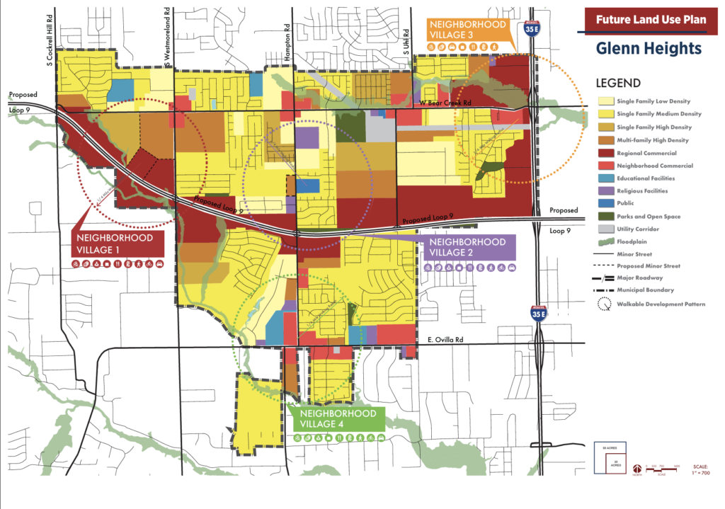
The amended map retains regional commercial areas along those corridors, but much of the remainder of the city is designated for single-family housing, multifamily development, industrial property, educational facilities, parks, public property, utilities or floodplain.

Smaller areas are designated for neighborhood commercial development, which could include offices, pharmacies, salons and other businesses intended primarily to serve nearby residents.
The regional commercial designation is intended for larger retail and office development capable of drawing customers from outside Glenn Heights. Those sites are now concentrated primarily along Loop 9 and Interstate 35E.
Even those designations do not guarantee that commercial development will occur.
The Future Land Use Map remains a policy guide. A future City Council could approve another use, amend the Comprehensive Plan or agree to different standards through a planned development.
Protecting what remains will depend on future zoning decisions, not merely the colors adopted on the map Tuesday.
Vacant does not mean available
The amended map includes approved developments that have not been constructed. Some may not begin for years, and others may never be completed.
That does not automatically return the property to the city’s pool of potential commercial land.
Rezoning property does not authorize immediate construction. Developers must still complete applicable site-plan, permitting and infrastructure requirements before work begins.
But once property has been rezoned or incorporated into a planned development, the approved use remains unless it expires under an applicable condition or is changed through another zoning action.
A parcel can therefore remain visibly empty while no longer being available for the commercial future shown on an older map.
Changing it back would generally require action from the property owner and another public zoning process before the Planning and Zoning Commission and City Council.
Nearly 3,000 additional homes
The reduction in commercial flexibility comes as Glenn Heights continues preparing for substantial residential growth.
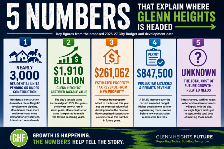
A previous Glenn Heights Future review of city records identified 2,960 single-family and multifamily units that were approved, pending or under construction earlier this year.
That total included 1,673 single-family lots and 1,287 multifamily units. If all are completed and occupied, the additional housing could push Glenn Heights beyond 30,000 residents.
More rooftops could make the city more attractive to grocery stores, restaurants and retailers that depend on nearby households and traffic.
But rooftops are only one part of the equation.
Commercial development also requires land with appropriate zoning, roadway access, visibility, utilities and enough space to support the proposed use. Population growth cannot produce a grocery store if the sites best suited for one have already been committed to housing or another development.
Glenn Heights is therefore facing the cumulative result of its own growth strategy: New residential development may create the customer base businesses want while consuming some of the land those businesses would need.
Lower density standards for future proposals
The council also amended the residential density categories in the Comprehensive Plan.
Single-family low density was reduced from one to four homes per acre to one to two. Medium density changed from four to nine homes per acre to three to four, while high density changed from nine to 12 homes per acre to five to six.
The multifamily designation was reduced from a range of 12 to 40 units per acre to a maximum of 25. Townhomes and duplexes may be considered within the multifamily category at densities of up to 18 units per acre.
The changes bring the Comprehensive Plan closer to the density ranges in the city’s zoning regulations and will guide future development requests.
They do not undo developments already approved under previous zoning decisions.
Developers may also continue requesting planned-development standards that differ from the Comprehensive Plan. The Planning and Zoning Commission and City Council will decide whether those requests should be approved.
A narrower path forward
A new map cannot reverse years of zoning decisions.
Some approved developments may not move forward. Property owners may eventually request different uses. Loop 9 could create new commercial opportunities, and future annexation or redevelopment could change the city’s options.
None of those possibilities changes the city’s current position.
Glenn Heights has approved thousands of additional homes. Much of its land is already developed, zoned or committed. Because it did not reflect zoning changes and planned developments approved since 2019, the previous Future Land Use Map gave residents an incomplete picture of how much freedom the city still had to determine what would happen on property that appeared undeveloped.
The amended map presents a more accurate picture of the city those decisions have produced.
Residents still want a grocery store, restaurants, retail and more services. City officials continue to identify commercial development as a priority.
But supporting commercial growth requires more than expressing support for it. It requires preserving land where it can happen.
The decisions that fundamentally shaped Glenn Heights’ remaining options have already been made.
What city leaders do with the land that remains will determine whether residents finally receive the commercial development they have requested — or whether Glenn Heights continues adding rooftops while its residents continue spending their money somewhere else.